top of page

2D, 3D MAPPING TOPOGRAPHIC SURVEY
2D, 3D MAPPING TOPOGRAPHIC SURVEY
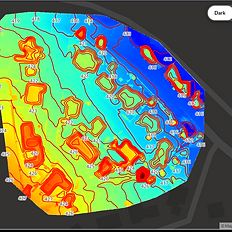
We produce multiple types of maps including 2D, 3D & Orthmosaic, Topography Surveys
1 hr1 hCustomer's Place
Contact us for Quote
Contact us for Quote
Service Description
Aerial maps include benefits from monitoring progress, understanding a site’s layout, measurements, Site Over view, project planning and more. The level of data and precision Drone maps can provide are remarkable and will address the needs of your business, Providing different types of maps like Orthophoto, DSM, DTM, Contour Lines, Point Clouds and more.


Contact Details
787-359-4004
info@airtechdynamics.com
Cayey, Puerto Rico
bottom of page